
Hotline: +84 971 443 717
Français


Tailor Made Holidays with our travel experts
We'll do our best to call you within 48h
ROAD TRIP DETAILS:
Route: Sapa to Ha Giang on back-roads
Total Distance: 485km
Terrain & Scenery: mountains, valleys, rivers, minority villages, borderlands
Road Conditions: paved rural back-roads, occasional gravel roads, highways
ABOUT THIS ROUTE:
Section 01: Sapa to Muong Khuong (85km)
Section 02: Muong Khuong to Bac Ha (90km)
Section 03: Bac Ha to Xin Man (170km)
Section 04: Xin Man to Ha Giang (140km)
I’ve written this guide in 4 sections, going west to east from Sapa to Ha Giang, but the route can be ridden in either direction. Note that each section doesn’t necessarily correspond to one day on the road. The total distance is 485km. I recommend spending between 3-5 days on this route. Remember that on these small, twisting mountain roads progress can be slow, averaging around 30km an hour. If possible try to time your trip to coincide with a weekend, as all the towns on this route have lively markets, which draw colourfully-dressed ethnic minorities from across the region. Weather in the mountains is very erratic, and even in the summer months temperatures drop significantly in the evenings. Spring and autumn are the best times to go, the latter coinciding with the bright colours of the rice harvest. You can easily turn this route into a loop by connecting roads QL279 and QL70 for a faster return leg between Ha Giang and Sapa. Alternatively, you can continue north from Ha Giang for the spectacular Extreme North Loop. In my guide below I’ve included a description of the route, directions and places to stay and eat.
Note: At the time of writing (2015) the road between Bac Ha and Xin Man, which has been under construction for many years, is now mostly finished. However, there’s still a 5-10km section that is rough and bumpy, making it especially difficult in rainy or muddy conditions. I’ve marked this road on my map with a red line. My advice is to see what the weather is like, and ask locals in Bac Ha about the current state of the road, before deciding to take it. Personally, I prefer to follow my alternative route in section 3 of this guide which, although longer, is just as scenic.
SECTION 01:
Route: Sapa to Muong Khuong | Distance: 85km
The first section of this road trip is all on Road 4D, which heads northeast of Sapa, down to Lao Cai on the Chinese border, and then up a long mountain pass to the little visited outpost of Muong Khuong.
Leave the mountain resort town of Sapa by way of the Sapa Pass. This scenic winding road takes you down to the Red River valley, which is noticeably warmer (and a lot less cloudy) than Sapa. The dusty but busy town of Lao Cai sits right on the Chinese border. It’s a major gateway for trade between the two countries, especially now that a new highway has opened, linking Lao Cai with Hanoi. Apart from soaking up the strangely compelling atmosphere at the border bridge, there’s not much else to hold your attention in this city. Shoot across the muddy waters of the Red River and head northeast out of Lao Cai on Road 4D. After 10km take a left turn (due north) signposted to Muong Khuong.
The early stages of this road don’t promise much. The road surface has been badly grazed and trucks clog the corners, squeezing past each other on their way to and from construction sites in the mountains, where ambitious new roads to remote settlements are being laid.
However, after 20km the road quality improves and so does the scenery. Leaving the valleys behind Road 4D aims skyward, not stopping until it’s over 1,000m high. Waterfalls and streams gurgle by the roadside, inviting you to wash the dust from your face, before gliding along the last 10km – a spectacular ride next to a terrifying drop – to Muong Khuong town.
Just a few kilometres from the Chinese border, Muong Khuong is a strange and isolated place. Hemmed in on all sides by a ring of limestone pinnacles, it’s a mythical setting for an ugly town. Ugly, but interesting. Muong Khuong was a remote outpost during French colonial times, and there are still a few crumbling buildings left from that era (although they are soon to be demolished). Much of the town was destroyed during the 1979 border war between Vietnam and China. There’s a good market on weekends that attracts many of the ethnic minority groups living in the vicinity. A couple of OK nhà nghỉ (guest houses) can be found on the high street (click HERE for more information about guest houses). The imaginatively named Nha Nghi 386 (Tel: 0986 347 467) is right by the market and has large but dull rooms for 200-300,000vnđ ($10-15) a night. There’s not much food available, but you can still find a few empty rice eateries (quán cơm) along the main drag. Although I wouldn’t linger in this town long, I find it a fascinating place to be for a night.
SECTION 2:
Route: Muong Khuong to Bac Ha | Distance: 90km
The journey between Muong Khuong and Bac Ha is only 90km, but it can take all day because the roads are extremely mountainous. Following the Chinese border for much of the way, Road TL153 climbs up and down several mountains, connecting dozens of small minority villages and remote army outposts, before heading south to the famous market town of Bac Ha.
It’s a good idea to start reasonably early in the morning from Muong Khuong. Take Road TL153 northeast out of town. Almost immediately the road carves a path along the edge of a high precipice; above waterfalls, terraced rice fields and tiny hamlets far down in the valley below. Most of this section has only recently been paved. Finishing touches are still being put in place, and already there are regular landslides that cover the road surface in boulders and earth. If you’re lucky enough to have good weather it’s a dramatic ride all the way to Bac Ha.
At Pha Long – the northern-most point of this route – there’s a lively, rustic market on weekends. From here the road turns south, following the course of the My Phu River, along a spectacular valley dominated by limestone mountains. China is on the other side of the river. It’s very apparent that, on the Vietnamese side, all land is cultivated – from the river banks to the mountaintops – whereas, on the Chinese side, there’s hardly any sign of human activity; no roads, fields or buildings, just a bare mountain wall. Apart from the great views, I love the strange feeling that comes from being so close to the border of a country as big as China.
Leaving the Chinese border behind, Road TL153 corkscrews over several passes before reaching the alpine settlement of Si Ma Cai. Set on a lovely crest of land surrounded by steep peaks reaching over 2,000m, this is yet another strange town in the middle of nowhere. The original town is no more than a crossroads, but there’s now a vast new town with wide boulevards, empty squares, and over-sized government buildings. Massive construction is ongoing. If you feel like stopping for the night, there’s a decent guest house right at the town’s crossroads: Nha Nghi Hong Nhung (0987 225 228), 200-400,000vnđ ($10-20).
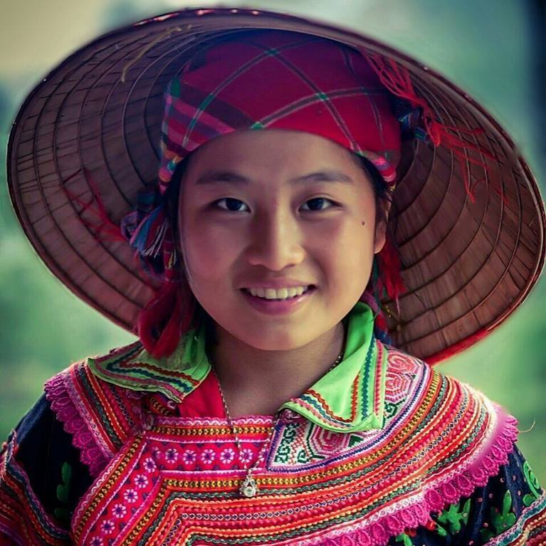
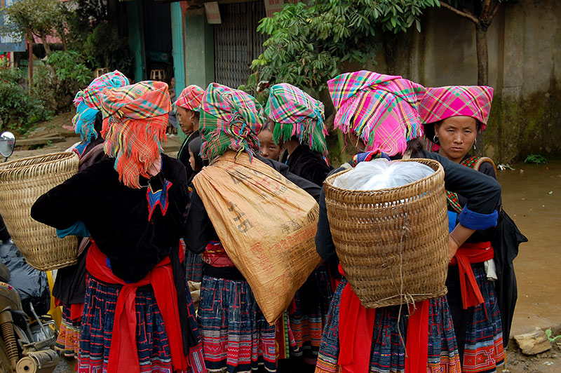
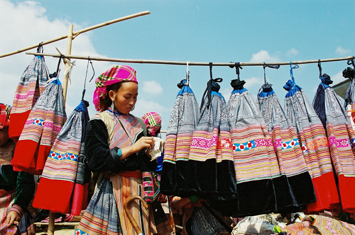
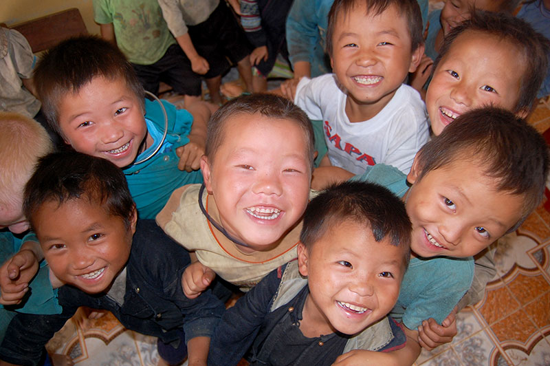
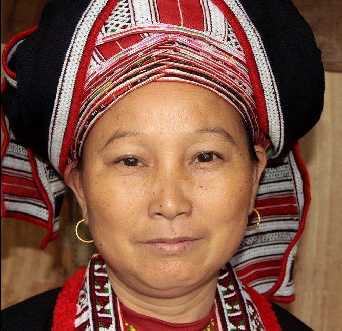
The ascent out of Si Ma Cai is so steep that your motorbike may struggle if there’s a passenger on the back. It can get very cold at the top, but the views are outstanding once again as the road continues south. It’s interesting to note that, although this is one of the more remote parts of Vietnam, the population density is surprisingly high. There’s always some activity going on in this big landscape; people working in the fields, walking along paths to isolated homes on the mountainsides, herding cattle, chopping wood in the forests. Most of these people are from Vietnam’s ethnic minorities. With over 50 different ethnic groups, these minorities only make up 14% of the country’s population, but they are concentrated in highland areas, especially in the north. Most minority people make their living from agriculture. Such is the density in Lào Cai Province that there’s hardly any ‘unused’ land; the entire landscape is cultivated. Minority children are always excited to see foreigners. It’s a good idea to carry some candy with you to offer these kids (as an alternative to money) and put wide smiles on their faces.
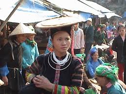
Descending through pine trees, the town of Bac Ha comes into view. Bac Ha’s Sunday Market has become a favourite attraction for foreign and domestic tourists alike. Every weekend, thousands of minority people – the women all dressed in brightly coloured traditional clothing – make the long journey on foot from their homes in mountain villages to the market. If you happen to be here on a weekend this market is quite a spectacle. There’s a hot food section where minority men eat delicious bowls of noodles, smoke bamboo pipes and consume large amounts of potent local liquor. Meanwhile, the women wander through the market’s wide spread of stalls, buying clothes, food, and supplies for the week ahead. It’s a lively, vibrant market with lots to see. However, try to get here as early as possible because, from about 9.30am, hundreds of tourists arrive on buses, armed with big SLR cameras with giant detachable zooms, that many proceed to stick in minority women’s faces; suddenly it feels more like a zoo than a market. (Read my guide to Bac Ha Market HERE)
There are plenty of places to stay in Bac Ha. I like the Sunday Hotel (Tel: 0904 646 955; 200-500,000vnđ [$10-25] a night) on the main square, just a stroll away from the market. There are food options around the square, including some hotel restaurants which have English-language menus.
SECTION 03:
Route: Bac Ha to Xin Man | Distance: 170km
There’s a more direct route between Bac Ha and Xin Man (also known as Coc Pai) than the one I outline here. The road, which has been under construction for years, is now in good condition, apart from a 5-10km section, which is still rough and bumpy. I’ve marked the road in red on my map. You can ask around in Bac Ha for up-to-date information about the state of this road. However, even when it’s completely finished, it’d be a shame to miss the longer route to Xin Man, because it’s a beautiful drive.
This is the longest section of the road trip, so leave early and give yourself plenty of time to reach Xin Man by nightfall. Leave Bac Ha on Road TL153 heading south, down a long and scenic mountain pass to Highway QL70. Turn left (due southeast) and continue for 40km to the crossroads town of Pho Rang. Until the opening of a new expressway in September 2014, this meandering road was the main highway between Hanoi and Lao Cai. It was hopelessly narrow to accommodate all the trucks plying between the capital and the Chinese border, not to mention all the tourist traffic heading to Sapa on weekends. Nowadays, with all heavy traffic taking the new expressway, QL70 is an enjoyable ride, threading through a very lush landscape of fruit trees, red earth and hamlets of wooden houses on stilts.
Pho Rang makes a convenient lunch stop before heading north once again on Road QL279, signposted for Bac Quang. After crossing a bridge over the Chay River – the course of which weaves in and out of this entire route – this excellent road leads through a peaceful, verdant landscape, characterized by rice fields, different kinds of palm tree, and attractive rural hamlets clustered around clear rivers.
After 25km the road bends east, entering Vietnam’s northern-most province, Ha Giang. Unfortunately, the border between provinces is made apparent by the immediate deterioration of the road surface. Smack on the provincial border asphalt turns to mud and rocks: welcome to Ha Giang.
However, you only need to put up with the bumpy ride for 10km before reaching the town of Quang Binh (also known as Yen Binh). Look out for a signpost to the left (due north) for Na Tri just before crossing a small bridge. Under the signpost there’s a milestone for Coc Pai (Xin Man) so you’ll know you’re on the right road. This is Road TL178. It heads north, leading through a gorgeous valley, up a mountain, and down the other side to Xin Man town, near the Chinese border. In good weather, this small back-road is my favourite part of the road trip; a rich, verdant valley of terraced rice fields, surrounded by high, forested mountains, spouting waterfalls which run into streams leading through pretty villages of wood and thatch homes.
There’s a new home stay option near Na Tri village (look out for the signboard for Làng Mới), but if the sun is out I’d continue on up the spectacular mountain pass leading straight over the Chay River Massif. At times this pass is so steep that all vehicles struggle against the gradient. Near the summit the road surface is pretty bad but only for a few hundred metres. The air is thin and cool at the top. The views north and south are very grand.
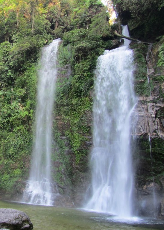
Descending the other side through thick forest there’s a tree by the roadside with a small altar next to it. A plaque announces that this tree is over 500 years old. A few minutes further down is Tien Waterfall. Reached via steep steps through a bamboo forest, this is a beautiful cascade of blue water fresh off the mountains. You can swim in the (cold) pool below the falls. There’s a small cafe at the entrance where you can also stay the night (150,000vnđ [$7]) but the rooms aren’t great.
The long descent to Xin Man town offers terrific views of mountains receding into the distance (which is Chinese territory) in shades of purple and blue. The road echoes the course of mountain streams, each one becoming increasingly bloated on the way down as they’re joined by other watercourses. During harvest time (September-October) the hillsides are covered in bright yellow rice terraces. Children wave from the roadside, buffalo carry wooden carts full of hay, and men and women are busy working in the fields. It’s a wonderful sight and one that you wouldn’t see if you took the short route between Bac Ha and Xin Man.
The town of Xin Man is built on a steep slope. There’s a relative glut of accommodation on the high street here. Choose from half a dozen nhà nghỉ (guest houses) and hotels. I like the large, clean rooms with balconies at Nha Nghi Ngoc Son (29 Le Duan; Tel: 0972 307 999; 200-400,000vnđ [$10-20] a night). There are some standard cơm phở (rice and noodle) eateries serving hearty meals for 60-150,000vnđ ($3-7). On weekends there’s a large market, and even on weekdays this is a good place for a local breakfast of noodle soup. Xin Man is remote – it’s a 2-3 hour drive in any direction to the nearest main road or city – but the people are friendly and, if you arrive on a weekend and find a good room, you might want to spend a couple of nights here.
SECTION 04:
Route: Xin Man to Ha Giang | Distance: 140km
The journey from Xin Man to Ha Giang follows the course of two rivers. First, a rarely used road near the Chinese border clings to the valley of the Chay River, heading east then south to join Highway QL2, which leads north along the Lo River towards China once more, stopping 20km short of the border at Ha Giang, the provincial capital.
Head east out of Xin Man on Road TL178. It’s 100km from Xin Man to the junction with National Highway QL2. The first half of this road is pretty bumpy and progress can be quite slow. Although the second half is in much better condition it’s extremely mountainous which, once again, will slow you down. Expect the first 100km of this section to take 3-4 hours, not including stops. From Xin Man to Hoang Su Phi (also known at Vinh Quang) Road TL178 glides high above the galloping cascades of the Chay River. To the north is a wall of mountains, the other side of which is China.
The isolated town of Hoang Su Phi sits in a steep valley like trash in a landfill. On a rainy, grey day it looks very grim indeed. A couple of nhà nghỉ (guest houses) on the high-street and the large Sông Chảy Hotel are available if you get stuck here for a night. Food is also available and it’s a good idea to take lunch here before continuing southeast again on Road TL178.
The road surface is smoother for the next 60km to the junction with Highway QL2. The scenery is better too. Two high passes – called Heaven’s Gate Pass 1 and 2 – zigzag up through terraced rice and tea plantations. The tea is a special variety with a white flower, called trà shan tuyết. Look out for roadside shacks selling it. The second Heaven’s Gate Pass is the more thrilling of the two. Views over terraced crops, waterfalls and rivers are majestic. Even in the ghostly mist that often hangs over the pass, it’s a sublime ride and a fitting end to the big landscapes on this route; for once the road drops down to meet Highway QL2 it’s a smooth, quick drive north along the Lo River to Ha Giang.
I like Ha Giang. Built on the banks of the Lo River this city has wide roads, good, plentiful food, a large market, and lots of accommodation options. You need to choose which side of the river you want to stay. Nguyen Trai Street runs along the west side of the river, while Nguyen Thai Hoc follows the east bank. There are hotels along both streets and a bridge over the river at either end. I prefer the east side, on Nguyen Thai Hoc Street, because there are more food options here and a couple of good guest houses right on the riverfront. Nha Nghi Thuy Tien (19 Nguyen Thai Hoc; Tel: 0913 271 248) has good but aging rooms with balconies overlooking the river for 200-400,000vnđ ($10-20) a night.
On Nguyen Thai Hoc there are dozens of rice eateries where you point and order. These offer decent food for around 40,000vnđ ($2) per person. I am particularly fond of this one, but it has changed its decor since I last visited. If you’re looking for a feast and some relatively fancy dining after a few days of ‘mountain food’, try the big restaurants on Nguyen Trai Street, on the right hand side just north of the second (northern) bridge. Here you’ll find local specialities, such as salmon hotpot (lẩu cá hồi) for which the region is famous.
From Ha Giang you could easily complete a loop, heading back to Sapa, by connecting highways QL2, QL279 and QL70 to Lao Cai. Alternatively, you could continue north from Ha Giang on the spectacular Extreme North Loop.